May 10, 2023
A New Approach to Modeling Commutes and Access in Our Cities
Getting around any megacity as dense and vast as Cairo, Egypt can be a challenge, even for the most able-bodied, well-traveled, and well-informed commuter.
This post was written in collaboration with New Urban Mobility Alliance (NUMO) and Transport for Cairo.
The plethora of options for transport modes and routes has made it difficult to decode and accurately predict commute times in many places. Let us take the case of Nour, a hypothetical 26-year-old resident of an East Cairo suburb. Nour’s commute downtown to get to work on an average day might start with a short walk and a bus ride to the nearest metro station, followed by a 20-minute ride underground, and then a check of several micromobility apps for the availability of a scooter or shared bicycle to finally reach their work. This trip could take between 45 and 55 minutes, and is reversed at the end of each day. One might think that driving would improve the efficiency of Nour’s commute, but estimating this timing can also be highly unpredictable, given the volatility of congestion and parking.
With the growing availability of data points on real car speeds, cycling infrastructure, and micromobility supply, however, we now have the power to more accurately decipher and model the experiences of average commuters (like Nour) to better inform transport planning. For most planners and decision-makers, their current understanding of the realities of urban commutes is still based on opaque models with multiple theoretical and unchecked factors. This no longer has to be the case with access to more accurate data and improved analysis methods. As our commutes continue to evolve, it is crucial that planners utilize more comprehensive, precise indicators to create realistic assessments of how people travel in order to better understand who is served (or excluded) by current transport options, as well as how changes in transport and land use can impact peoples’ ability to earn a stable livelihood.
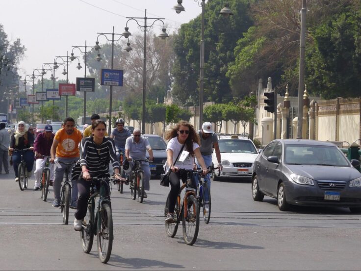
To improve access to jobs, cities need to focus on integrating and enabling stronger connections between modes of micromobility and public transit systems.
Accounting for Micromobility and Realistic Car Travel
In All Possible Commutes: How Micromobility and Realistic Car Travel Times Impact Accessibility Analysis, a new paper from the New Urban Mobility Alliance (NUMO) produced with support from Transport for Cairo and ITDP, the authors propose that micromobility, considered realistically, makes a major difference in people’s access to their cities. ‘Considered realistically’ means accounting for multi-modal and connected trips by bike and public transit; limiting micromobility travel to safe cycling infrastructure; and considering micromobility supply constraints in devising accessibility improvements. Micromobility, typically defined as the use of small, electric- or human-powered devices that operate below 25 kilometers-per-hour, has been gaining momentum as a more sustainable and affordable alternative to driving. Bicycles, e-bikes, and e-scooters are some of the most popular micromobility options, with the gradual global recovery from the COVID-19 pandemic prompting a new surge in people cycling, walking, and scooting in cities.
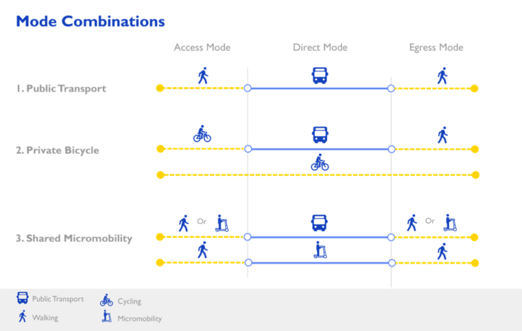
As a growing component of many people’s commutes, especially for first- and last-mile connections, micromobility needs to be better accounted for when developing mobility policies. As presented in All Possible Commutes, the current approach to accessibility analysis utilized by planners and officials needs to be reconsidered to reflect more realistic, up-to-date travel patterns and the micromobility usage of modern commuters. The paper’s methodology also incorporates real-world traffic speeds and parking times when calculating access by car to show that, under real-world conditions, the gap between commuting by bike and public transit compared to driving is often smaller than it appears in traditional accessibility analysis. When it comes to urban access, the combination of commuting by public transit and micromobility has the potential to be competitive with driving in a way that neither mode can be by itself.
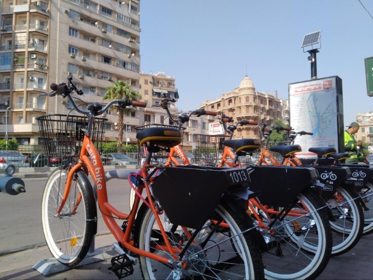
The findings presented in All Possible Commutes provide novel contributions to the study of urban access by being the first paper of its kind to collectively account for:
- high-quality, real-world traffic speeds;
- people’s willingness to cycle on variable infrastructure (e.g. not along large highways); and
- transfers between micromobility and public transit.
The paper’s methodology, datasets, and case studies present stakeholders with an updated approach to accessibility analysis that can inform much more precise and responsive planning and policy decisions.
The Case for Rethinking Accessibility Analysis
Accessibility analysis can be a powerful tool for evaluating how mobility measures enable people to travel to various destinations, allowing planners a deeper understanding of what systems work well and what needs improvement. As current analyses often do not incorporate micromobility, we have a limited understanding of the existing and potential effects of these modes on actual access within cities. Additionally, some analyses of accessibility use theoretical, free-flow travel speeds for cars, rather than incorporating congestion, the time it takes to access a car, park near a destination, and travel from a parking spot to a destination. These omissions can lead to overestimations of accessibility by car, making cars falsely appear faster than other modes in some instances, and hinging outcomes on unrealistic assumptions that leave out other travel modes.
In All Possible Commutes, case studies of several major cities are examined: Cairo, Egypt; Mexico City, Mexico; Minneapolis-Saint Paul, USA; and the San Francisco Bay Area, USA. The cases compare the results of accessibility analyses conducted with and without proposed methodological improvements that incorporate micromobility and accurate car travel times. In these case studies, the authors assessed job access in particular, due to the availability of data on job destinations and the specificity and frequency of travel to and from work destinations for most people. To realistically represent travel, the authors routed micromobility trips only on roadways where users were likely to feel comfortable using those types of vehicles, and incorporated possible constraints on the availability of micromobility vehicles.
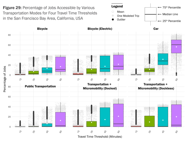
These case studies revealed a clear pattern: micromobility was competitive with cars for trips under 15 minutes, but competing with job access by car at 30-, 45- and 60-minute travel time thresholds required a combination of both micromobility and robust public transit. In other words, the quality of the public transit in a city had a major influence on the extent to which micromobility increased job access. The authors also analyzed the extent to which increases in job access as a result of micromobility were equitably distributed among people of different races or ethnicities and income levels. In the San Francisco Bay Area and Minneapolis-Saint Paul, micromobility improved job access more for lower-income residents than for the average resident. In San Francisco, micromobility led to a more equitable distribution of job access across areas of the city.
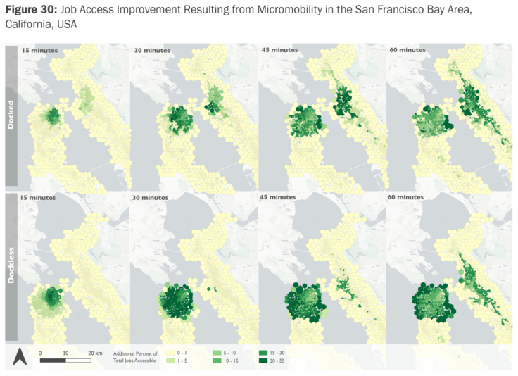
These findings provide policymakers, city agencies, and researchers with a framework for making transport systems more equitable, accessible, and efficient.
Job access improvements due to micromobility extended far beyond the micromobility service area, often clustering around major transit lines. This is because residents of peripheral areas could connect from public transit to micromobility in urban cores, gaining better access to jobs in downtowns. There were two key scenarios in which micromobility more definitively improved job access or rivaled job access by car: shorter trips in cities with congested urban cores, and longer trips (over 30 minutes) in large metro areas with robust public transit networks. Accounting for parking, access, and egress times, job access by car notably decreased, especially for shorter travel times for which these factors represent a larger portion of the car trip.
At the same time, the paper found that micromobility modes can significantly increase job access as a first- and last-mile connector to public transit, emphasizing the importance of expanding micromobility to areas that would also benefit most from improved transit access. In addition, working to make roads safer and more friendly to micromobility in general could help increase job access and lower commute times. Overall, these findings indicate that cities can best leverage micromobility travel to improve access to jobs if they also place a focus on integrating and enabling stronger connections between different forms of micromobility and public transit systems.
The findings presented in All Possible Commutes aims to provide city leaders, policymakers, transport agencies, and researchers with a framework for better measuring actual access to jobs via various transport modes, and to inform solutions that can help make infrastructure and public transit more equitable and efficient. By factoring in more comprehensive, up-to-date data on micromobility modes and realistic car travel times, cities can be better equipped to assess real-world commutes and create proactive, responsive strategies that promote sustainability, connectivity, and active mobility.
